Online Resources Help Researchers Tap Into TV & Radio Broadcasts

wdel tv
At one time WDEL in Wilmington also had a television broadcast station. Source: http://www.oldwilmington.net/oldwilmington/radio-tv.htm

There are significant online resources to help scholars and the public locate and use video and audio recordings of broadcasts, and we are seeing some great advances in this area.  One of those involves the Internet Archive, a source of web-based content since the late 1990s.  Beginning with printed matter and websites, the aggregator and digitizer quickly added audio and moving images to the initial holdings.

Now this virtual repository has taken another leap forward as it added television news from 20 different channels.  By collecting and preserving broadcasts, the Archive gives researchers easy access to network and local programs produced over the past 3 years.  Twenty-four hours after an airing, the latest show is added to the files.  But “The plan is to go back year by year, and slowly add news video going back to the start of television,” the New York Times reports.

This collection was inspired by Vanderbilt University’s Television News Archive, an earlier project to preserve and provide access to the news broadcasts from the national television networks.  Vanderbilt creates recording of news broadcasts and preserves the content for future generations while providing the widest access possible within the copyright limits.  This repository has recordings back to August 5, 1968.  Its core consist of regularly scheduled newscasts from ABC, CBS, NBC, CNN, and Fox News.

The Library of Congress is working to rescue shows shot on fragile videotape, the Washington Post Reports.  At the National Audio-Visual Conservation Center technicians are converting old videotapes, from the 1950s through the 1970s, into digital files.  The tapes with delicate coatings are in outdated formats, and programs were often erased as producers “were slow to realize that the initial records might have value in the distant future.”

wdel tv 1
A WDEL TV broadcast from Wilmington Delaware in 1950. Courtesy of oldwilmington.net
http://www.oldwilmington.net/oldwilmington/radio-tv.htm

Also the University of Baltimore’s Langsdale Library has the WMAR Collection, a source for news broadcasts from Maryland’s first television station.  The film and videotapes comprise broadcasts from 1948 to 1987.

And here is a link to the NBCUniversal Archive. 

These resources are going to be valuable as scholars and the public may easily access and leverage largely untapped broadcast records to peer into and reconstruct the past.
Duck and Cover: Remembering the Days of Fallout Shelters, Conelrad, and Sputnik in Harford County

I recently talked about the history of Civil Defense in Harford County for the library system there. The program examined homeland security from World War II to the time when planning for survival of an all-out nuclear attack started fading into the past.  Opening with an examination of World War II era blackout drills, plane spotter stations, and air raid wardens, the program quickly moved to the era when the stakes became higher, the nuclear age.  This was a time when air raid sirens wailed out signaling practice drills, Conelrad interrupted radio programs, government officials planned for the worst, and people contemplated building family backyard shelters.

While developing the program, I had a great time rummaging around Havre de Grace, Aberdeen, Bel Air, and other places looking for surviving artifacts and research materials from the Cold War.  Along the way, I came across forgotten fallout shelters, dusty emergency plans stashed away long ago, old photos, and maps.  And there was lots of vintage audio and video footage, such as Bert the Turtle telling schoolchildren to duck and cover.

We had an engaged audience and the exchanges were fascinating as we talked about evolving threats, planning priorities, and the tradeoffs.  The library patrons shared plenty of memories while we worked our way through the old emergency procedures, looked at the films and listening to some of the folk music from that era.

Online Historical Maps of Harford County

Over the past several years there has been an enormous increase in the number of historical maps that are available online.  These digital collections are a great aid for those of us seeking to understand the past, whether it is for a scholarly investigation, local history study, or genealogy project. While the maps, many centuries old, have been available in special collections repositories around the nation, the access was limited as trips to widely scattered archives created obstacles for most researchers.

Recently I needed to examine old drawings from Harford County, and I was able to easily access e-published renderings from a number of universities, historical societies, and libraries around the world.

There are a few helpful starting points, when accessing these primary sources.  One of the best is Old Maps Online, an easy-to-use web portal to historical maps in libraries around the globe.  It allows the user to search across a number of extensive collections, via a geographical search interface.  Another strong one is the Library of Congress.  The products can be downloaded and the scans, which are of high quality, can be magnified, in most instances.  Some of repositories require you to register to get full access.

These and other research e-resources are revolutionizing the way we conduct historical research and are invaluable for those working in the past.  Here are some sites for locating Harford County Maps online, as well as any other place you are examining.

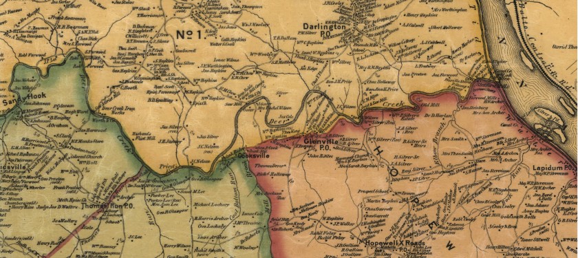
  • Searchable on Old Maps Online, the David Rumsey Map Collection has Simon J. Martenet’s Map of Harford County, along with dozens of other digital products.
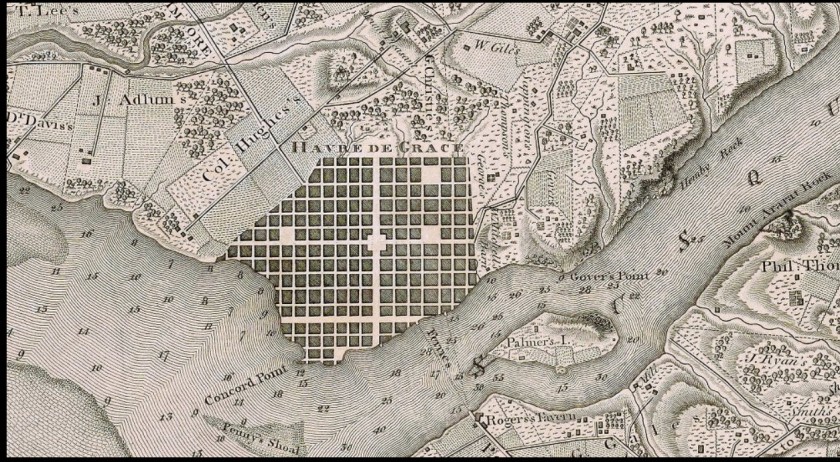
  • Old Maps Online also has Brown University Library’s C. P. Hauducoeur’s engraving of the head of the Chesapeake and Susquehanna River.  Of course, many more are found via this web portal.
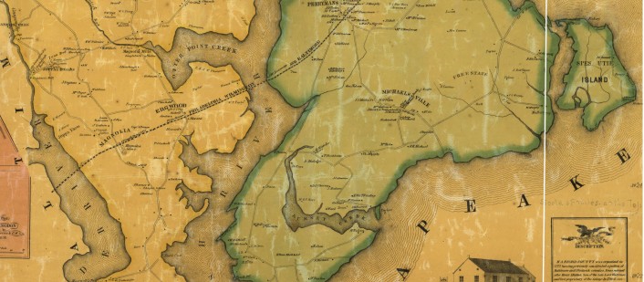
  • The Library of Congress has L. W. Herrick’s Map of Harford County from 1858 and Martenet’s 1878 Map.  It also has T.M. Fowler’s 1907 birds-eye-view of Havre de Grace.
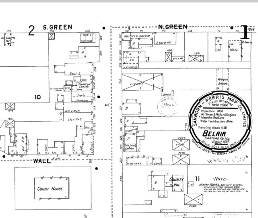
  • The Enoch Pratt Library has a subscription to the Sanborn Fire Insurance Maps. From the 1880s until about World War II, the cartographers for this company visited towns regularly to update drawings and produce sketches at a detailed scale of 1-inch to fifty feet.  With these a researcher is able to observe the changes that took place with a dwelling or a community over generations.  You need a Baltimore City Library card to access the database online.
  • Here is a link to a union catalog, an index, of all the Sanborn Maps published for Maryland.

Check these resources out the next time you are working on a project and need Harford County Maps.  Regardless of where your inquiry takes you you will find many other maps of interest as you start searching these and other databases.

A map of the head of Chesapeake Bay and Susquehanna River  by C. P. Hauducoeur; Source:  The John Carter Brown Library at Brown University, via:  Old Maps Online
A portion of the map of the head of Chesapeake Bay and Susquehanna River by C. P. Hauducoeur; Source: The John Carter Brown Library at Brown University, via: Old Maps Online
Sanborn Fire Insurance Map of Bel Air, 1897; Source Enoch Pratt Library
Part of the Sanborn Fire Insurance Map of Bel Air, 1897; Source Enoch Pratt Library
Harford County Maps, 1858.
A portion of the map of Harford Co., Maryland, 1858. Entirely from original surveys by L.W. Herrick; Source: Library of Congress
Martenet's Map of Harford County, Maryland, 1878:  Source:  Library of Congress
A part of Martenet’s Map of Harford County, Maryland, 1878: Source: Library of Congress